Jigginstown
Jigginstown:
Road: M7 at J10(also accessible to traffic on the R445)
Location: Newhall, Jigginstown, Naas, Co. Kildare
Date planned: 1986-2003
Photos:


Jigginstown very nearly claimed the title of Ireland's first motorway service station, which certainly earns it a place in our database.
Planning permission was first granted in 1986. It would have been built in the corner of the original layout of M7 J10, on the new Naas Bypass. Several variations of the plan were produced through to 1994.
The standard facilities would have been provided, including parking, toilets, a restaurant, a shop and a petrol station.
At the time, motorways were managed by the local authority, and there was no policy or definition of a motorway service area. It's therefore possible that, had this been built, it may have just been treated like a large petrol station. However, the developers explicitly promoted the proposal as "Ireland's first motorway service station", and newspapers made the same claim. The press compared the proposal to facilities provided in America.
No explicit reason was given for the project not being taken forward, but it's likely that no developer was convinced it would be necessary. It's important to remember that in 1986 Ireland had only a few miles of motorway, and even by 1994 the network consisted of only a few short stretches. As a result, what little long-distance traffic there was had many opportunities to take their break in any of the towns they'd be passing through. This is why no thought had been given to creating a policy on service stations.
When the National Roads Authority assumed responsibility for Irish motorways, they took a stance that their network didn't warrant any service stations. In 2002, Tougher Oil applied to build a motorway service area here, but it was refused. The NRA have since changed their stance but this land has not been chosen for development, and now that traffic levels have increased and the junction has been moved, it's unlikely to be proposed again.
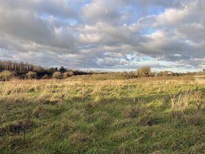
The land here is still unused, but the surrounding area is being developed.
Area Map
This is an automatically generated map of the surrounding area. The map tiles may take a moment to generate. You can use the button on the right to switch between a map and an aerial photo.
🗺 Grid reference: N867187 | See SABRE Maps for historic maps | See GeoHack for modern layers